Terzigno, località San Pietro.
Excavated 1992.
Nel 1992 in località S, Pietro a circa 390m s.l.m.,
nel Corso di una ricognizione Condotta all’interno di una cava abusive fu rinvenuta,
in un contesto sconvolto, una cospicua quantità di frammenti sparsi di anfore,
di dolii, di ceramica comune, di sigillata italica e
di cocciopesto, chiaro indizio della presenza di un impianto produttivo
agricolo, purtroppo distrutto dalle ruspe, il più alto finora rinvenuto nel territorio
di Terzigno, a conferma del noto passo di Strabone (V, 4, 8) che celebra le
pendici del Vesuvio coltivate fin quasi alla sommità e della nota pittura pompeiana
di larario, proveniente dalla Casa del Centenario (IX.8.6), in cui il vulcano monocipite e rappresentato ricoperto da filari di viti sorrette
da pali, con accanto Bacco metamorfizzato in un bel grappolo d’uva matura, nel
gesto di abbeverare la pantera.
In 1992 in the locality of S, Pietro at approximately 390m a.s.l., in the course of a reconnaissance conducted inside
an illegal quarry, a conspicuous quantity of scattered fragments of amphorae, dolia,
common pottery, Italic sigillata and earthenware were found in a disturbed
context, a clear indication of the presence of an agricultural production
plant, unfortunately destroyed by bulldozers, it was the highest so far found
in the Terzigno area, confirming the well-known passage from Strabo (V, 4, 8)
that celebrates the slopes of Vesuvius cultivated almost to the summit and the
well-known Pompeian lararium painting, from the Casa del Centenario (IX. 8 .6),
in which the single-headed volcano is depicted covered by rows of vines
supported by poles, with Bacchus metamorphosed into a beautiful bunch of ripe
grapes, in the gesture of pouring drink to the panther.
See Cicirelli, C.,
2017. Terzigno 1981-2016. Castellamare di Stabia: Nicola Longobardi, p.
20.
Plan
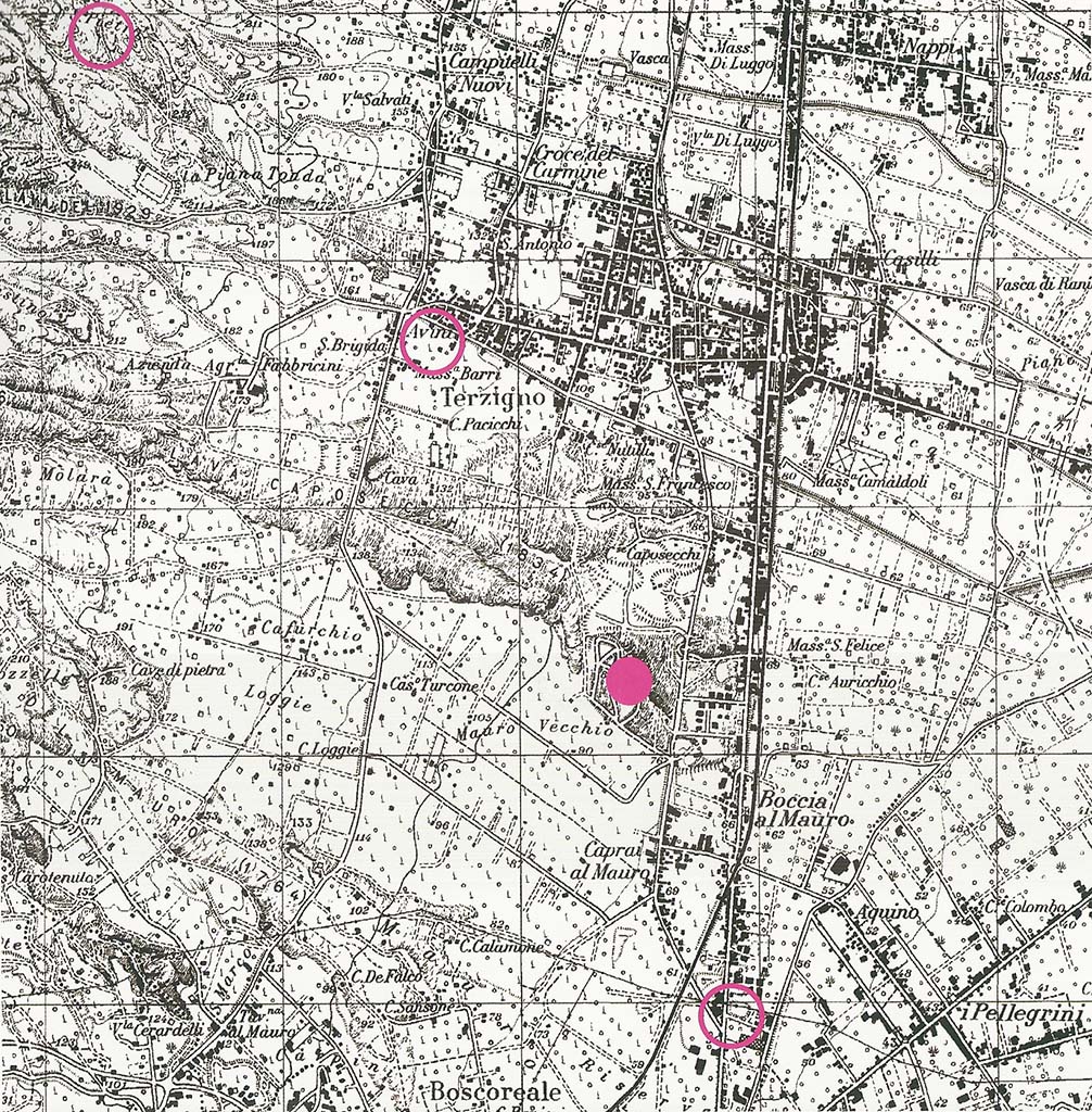
Terzigno, Località San Pietro. Terzigno archaeological
discoveries location plan.
Top left circle is Località San Pietro discovered in 1992.
Lower circle is remains in Contrada Avini discovered in
1976.
The solid circle is Villas 1, 2, 6 and other remains in Cava
Ranieri, Bocca al Mauro.
Altri archeologi di Terzigno
Gli scavi
archeologici promossi dal '700 in poi nel Suburbio pompeiano hanno riportato
alla luce innumerevoli ville rustiche di epoca romana, anche il territorio di
Terzigno, è stato, anche se solo recentemente (L. Reg. 67/88), interessato
corposamente da scavi che hanno rivelato numerosi ritrovamenti di seguito
cronologicamente elencati:
• Nel 1910, in località Scocozza masseria
Albano (oggi proprietà Pasquale Auricchio) sono stati rinvenuti delle mura
romane e vari attrezzi agricoli.
• Nel 1976, in località Avini cortile
Ferrara, a 21 metri di profondità, sono stati rinvenuti anfore e dolii romani.
• Nel 1981, in località Caposecchi, lungo
l'antica strada che da Pompei conduceva a Nola (Note 12), nella Cava Ranieri
('o tagliapret') che estrae la pietra della colata
lavica del 1832-34 (Note 13), è venuto alla luce l'intero quartiere rustico
(atrio porticato, corridoio, stanzette) e la cella vinaria di una villa romana,
la cella contiene dolii in terracotta con una
capacità di circa 800 litri, ben conservati, allineati e infossati a file
parallele con il marchio di fabbrica impresso sull'orlo. Questo rinvenimento fu
preceduto, nel 1976, da segnalazioni incerte di un'altra villa a circa 800
metri più a nord. Successivamente si sono avuti altri cinque rinvenimenti tanto
da formare un vero parco archeologico.
Lo sfruttamento dell'ager Pompeianus (seppur molto studiato negli ultimi
anni, data la pochezza delle informazioni, non è ancora del tutto ben definito
riguardo a estensione e configurazione) era assicurato da queste ville
rustiche. Situate su panoramiche terrazze naturali alle pendici del Vesuvio, le
ville furono distrutte dall'eruzione del 79 d.C., esse erano composte da una
pars urbana (riservata al padrone), una pars rustica (per i servi e l'attività
lavorativa), la fattoria era la pars fructuaria. Vi
sono anche esempi di ville più modeste solo rustiche (solo per vilicus e
schiavi).
Le ville romane
di Terzigno (Note 14), in sintesi, sono sei così distinte:
• villa 1: collocabile tra il II e il I
secolo a.C., di 135 mq. (tutte le pertinenze si estendono per 570 mq.), con 42 dolii nella cella vinaria e un deposito del foraggio (dove
sono visibili resti vegetali carbonizzati che i vari esami hanno stabilito
essere trifoglio, erba medica, fava e pisello selvatico), doveva trattarsi di
una grande azienda agricola;
• villa 2: a 800 metri dalla villa 1,
anch'essa collocabile tra il II e il I secolo a.C., qui sono stati trovati vari
scheletri umani e di cani, nonché vari monili, monete d'argento e bronzo, una
fibula di bronzo, tutto di buona fattura;
• villa 3: a 200 metri dalla villa 2,
consiste in un fondo di cisterna e qualche muro;
• villa 4: è una struttura muraria in opus
incertum, che delimita dei pavimenti di cocciopesto;
• villa 5: pochissimi elementi;
• villa 6: è risultata un rinvenimento
eccezionale, lo scavo esplorativo si è protratto dal 1993 al 1997, sono venuti
alla luce enormi e raffinati affreschi di cicli figurativi mitologici, di
Fortuna con timone, di Sacri Lari e di un Baccante e, nel settore rustico,
alcuni scheletri.
12. Nella
topografia del Suburbio pompeiano è questa un'antica arteria risalente al
periodo medioevale, quando il territorio di Terzigno insieme a tutto il
circondario era la "Silva Mala", luogo di caccia degli Angioini.
13. Fino al XVIII
secolo, questa strada resta l'unico collegamento tra le località del versante
meridionale del Vesuvio, con i Borbone si razionalizzò il tortuoso percorso,
quello attuale (la SS 268).
La strada è
riportata nella "Tavola Peutingeriana" (da Peutinger nome del
possessore della tavola che si trova a Vienna).
14. Il record
stratigrafico evidenziato nel sito, un'area di circa 500.00 mq., comincia con
depositi di flow e surge di 7900 anni fa e si chiude con la colata Caposecchi
del 1834, che poggia sulle lave 1701/1817, mentre i depositi vulcanici del 79
d.C. sono ad un livello moto più basso rispetto all'attuale piano di campagna.
Ampia e
dettagliata relazione sulle ville e catalogo completo dei reperti rinvenuti a
Terzigno sono riportati nella pubblicazione promossa dalla Gestione
Commissariale di Terzigno nel 1989: "Le Ville Romane di Terzigno " a
cura di Caterina Cicirelli.
Other Terzigno Archaeology
The archaeological
excavations promoted from the 18th century onwards in the Pompeian suburb have
brought to light countless rustic villas from the Roman era, even the territory
of Terzigno has been, even if only recently (Regional Law 67/88), heavily involved
in excavations which revealed numerous finds chronologically listed below:
• In 1910, in the località
Scocozza Masseria Albano (today owned by Pasquale Auricchio) Roman walls and
various agricultural tools were found.
• In 1976, in the località
Avini cortile Ferrara, Roman amphorae and dolii were
found at a depth of 21 metres.
• In 1981, in località
Caposecchi, along the ancient road that led from Pompeii to Nola (Note 12), in
the Ranieri quarry ('o tagliapret') which extracts the stone from the lava flow
of 1832-34 (Note 13), the entire rustic quarter (portico atrium, corridor,
small rooms) and the wine cellar of a Roman villa have come to light. The cella
vinaria contains terracotta dolia with a capacity of about 800 litres, well
preserved, aligned and sunken in parallel rows with the makers mark stamped on
the rim. This discovery was preceded, in 1976, by uncertain reports of another
villa about 800 meters further north. Subsequently there were five other
discoveries so as to form a true archaeological park.
The exploitation of
the ager Pompeianus (although much studied in recent years, given the paucity
of information, it is not yet fully defined in terms of extent and
configuration) was ensured by these rustic villas. Situated on scenic natural
terraces on the slopes of Vesuvius, the villas were destroyed by the eruption
of 79 AD. They consisted of a pars Urbana (reserved for the master), a pars rustica (for the servants and work), and the farm was the pars fructuaria. There are also examples of more modest
rustic villas (only for the steward and slaves).
The Roman villas of
Terzigno (Note 14), in summary, are six as follows:
• villa 1: datable
between the 2nd and 1st century BC, measuring 135 m2. (all the appurtenances
extend for 570 square meters), with 42 dolia in the wine cellar and a fodder
store (where charred plant remains are visible which the various examinations
have established to be clover, alfalfa, broad bean and wild pea). It must have
been of a large farm.
• villa 2: 800
meters from villa 1, which can also be dated between the 2nd and 1st century
BC, several human and dog skeletons were found here, as well as various pieces
of jewellery, silver and bronze coins, and a bronze brooch, all of good quality.
• villa 3: 200
meters from villa 2. It consists of a tank bottom and some walls.
• villa 4: It is a
masonry structure in opus incertum, which delimits the cocciopesto floors.
• villa 5: Had very
few elements.
• villa 6: It turned
out to be an exceptional find, the exploratory excavation lasted from 1993 to
1997, enormous and refined frescoes of mythological figurative cycles came to
light, of Fortuna with rudder, of Sacred Lares and a Bacchante and, in the
rustic sector, some skeletons.
12. In the
topography of the Pompeian suburb, this is an ancient artery dating back to the
medieval period, when the territory of Terzigno together with the entire
surrounding area was the "Silva Mala", a hunting place for the
Angevins.
13. Up until the
18th century, this road remained the only link between the localities on the
southern side of Vesuvius. The current winding route (the SS 268) was
rationalized with the Bourbons.
The road is recorded
in the "Tavola Peutingeriana" (from Peutinger, the name of the owner
of the table located in Vienna).
14. The
stratigraphic record highlighted in the site, an area of approximately 500.00
m2, begins with flow and surge deposits of 7900 years ago and ends with the
Caposecchi flow of 1834, which rests on lava of 1701/1817, while the volcanic deposits
of 79 AD are at a much lower level than the current ground level.
An extensive and
detailed report on the villas and a complete catalogue of the finds found in
Terzigno are reported in the publication published by the Gestione
Commissariale di Terzigno in 1989: "The Roman
Villas of Terzigno" edited by Caterina Cicirelli.
See http://ambrosioe.altervista.org/la_citta__-_copia.html